Thursday, 18 September 2025

Jersey

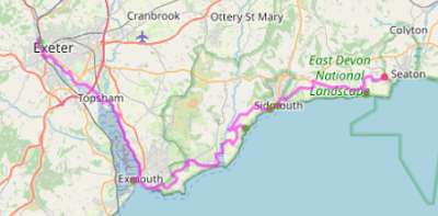
The ferry to Jersey was on time.  It was the same ferry we'd left last night, which had been to nearby St Malo overnight.  We met another couple of lovely cyclists, who had been delayed by the weather, with an extra three nights on Guernsey,  a scramble to find somewhere to stay, and missing three nights of their paid-for stay on Jersey.

Jersey looks different to Guernsey.   It was daylight, for a start.  But the approach was littered with jagged rocks sticking out of the sea, giving it a wild feel.  Once ashore, the town of St Helier feels like a modern spacious town, laid out in what seems a French style.  Maybe it had to be rebuilt after the war?   The harbour and town are at one end of a long crescent of a bay with miles of sand at low tide.

One of the harbours at St Helier
This is not strictly about cycling round the coast but might be interesting;   Liz and I improvised a ride to the west, along the bay and across an old railway line to the far side.  It was beautiful and culminated in an out of this world ride across a tidal causeway through jagged rocks to a lighthouse.  Jersey has a network of cycle routes and "green lanes" with a 15mph speed limit, where motorists have to give way to cyclists, pedestrians and horse riders.   We followed a couple of these back to the sea and had a lovely half day out with only gentle climbs.

Riding in Jersey is much like the UK, with a few twists:  The maximum speed limit is 40mph.  Traffic lights go straight from red to green, like in France. They don't have a lot of traffic signs: Give Way, No Entry and bus stops are just indicated by something written on the road.  All the street names are in French, but house names are mostly in English.  Many of roads on hills are called Mont de ...something ..., which is a bit off-putting at first.  It feels familiar, but just a little foreign as a place to cycle.

Jersey cycle routes


Round the island

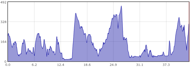
I rode round the island the next day.  Jersey is shaped a bit like a croissant, with the points facing down (south).  St Helier, the capital, is on the lovely southern bay,  towards the west end.  So I set off east along the bay towards St Aubin, at the west end of the bay.  The gentle railway walk we followed yesterday goes up a valley from here, but today I was going right to the south, so instead I had an alpine climb, with several hairpins, out of the village to the plateau and down to the point of the croissant, where there were several old WW2 gun emplacements guarding the approaches to the bay.
 
Leaving St Aubin

Guarding the bay
I was now in the Jersey National Park, which seems to stretch round the coast from the south east to the north west.  Just around the corner, a picturesque bay and the hamlet of Le Portelet, with the odd Bentley and Rolls Royce parked by the roadside.

Le Portelet 
After another vast sandy beach, St Brelade's bay, I came to the Corbiere lighthouse and the amazing tidal causeway that we visited yesterday, but didn't cross it this time, instead continuing round the coast.  Mostly quiet road with a couple of sections of heathland pathway, to get to Le Braye, another beach with miles of sand. I was a third of the way round, and it was coffee time.

Tidal Causeway to Phare Corbiere
I let Liz go first, in case it was dangerous 
St Brelade's Bay
Leaving the flatlands and Le Braye beach
Easy cycling north along the beach, with a few sand dunes and a decent tail wind for company, until I reached the eastern point of the island.  After this I climbed up on to the plateau and rode across the north of the island, mostly on the high ground.  There was the odd swerve down to a little rocky cove, pretty little places with a bit of sand.  And then, inevitably, back up again: a couple of the climbs were pretty serious with a few hairpin bends.  

Giant Puffins!  (Guernsey in the distance)

North coast

Greve de Lecq
Rozel Harbour
Eventually, I was on the west side, St Catherine's, with views of France - the Cotentin (Cherbourg) peninsula not far away.  From there it was pretty flat, and there were some small sandy beaches.   St Catherine's had a huge breakwater/pier, like Lyme Regis on steroids.  My favourite place on the west was Gorey bay, with a pretty harbour overlooked by a big castle.
 
Gorey bay
After Gorey I was on the main A3 and A4 coastal roads, not that busy but a bit boring for a few miles, until I got to the south of the island again and pedalled back alongside the beach to "home" at St Helier.  It was a brilliant day out, very varied countryside and coastline, plenty of hills, and some interesting wildlife.  I saw a red squirrel at St Brelade, and a black squirrel in the North somewhere, and a bit later I think I saw a snowy owl flying over a field.   However Google says they are not found in Jersey, so maybe it was a seagull.  Easily confused.

We came to be very fond of Jersey, its scenery, roads, drivers and the friendly people we met.  The ferry journey back to Poole with DFDS was calm and uneventful, but the following day's ferry was cancelled due to high forecast winds, so we were pleased to have dodged that one.

Tuesday, 16 September 2025

The Channel Isles!

You may have noticed that I missed a bit of coastline on my last trip.  The Channel Isles are reached by ferry from Poole or Portsmouth, but when I was passing earlier this year, the ferry times weren't convenient,  and anyway, they don't seem to encourage un-booked trips.  So I devised a plan to visit the two largest islands, Guernsey and Jersey, in September, and booked ferries in advance.

It's complicated.   You're supposed to go to one or the other, for, say, a week. Ferries don't run every day, and are operated by different companies.  My plan was to spend a day cycling round Guernsey, hop over to Jersey, another day riding round, and come home.  Three ferries, Monday, Wednesday and Friday, seemed to work.  I asked Liz if she'd like to join me, and she said yes.

I looked at going to the smaller islands: Alderney, Sark, Herm; but it doesn't seem possible to take a bike to them.  Cycling is simply not allowed on little Herm (about 1 × 0.5 miles), and you can send a bike by separate boat to tiny Sark (3.5 × 1.5 miles) but it's a lot of fuss.  (Actually, I later discovered you CAN take a bike to Alderney.)

Ferries, accommodation,  trains all booked, and after a few months of long hot dry summer, it was nearly time, when the weather changed.  On the previous Friday evening, an email informed me that the Monday ferry was cancelled due to adverse weather.  We'd been re-booked onto the Tuesday ferry instead.  Cue gnashing of teeth, but also some relief on my part because Liz doesn't like rough ferry crossings.  Maybe it was for the best.

Plan B:  Ferry to Guernsey Tuesday (arrive 17.15), one night in hotel, ferry to Jersey Wednesday (depart 10.00), and the rest of the trip unchanged (so far).  It must be one of the shorter holidays in Guernsey,  but I decided that I'll have to come back another time, as the option of riding round the island overnight didn't really appeal.

Ferry

The ferry crossing, on a whizzy catamaran thing taking cars and vans, was one of the rougher crossings I've been on, and we arrived shaken but not stirred, only half an hour late.

Welcome to Guernsey


St Peter Port

First impressions of Guernsey from the ferry were of a fairly low-lying island, but they weren't entirely accurate.  We were first off the ferry, and after speeding along the harbourside we found the last half a mile was steeply uphill through the narrow, haphazard streets of the old town to our guest house.  After a lovely meal nearby, we saw the sights of St Peter Port by the light of the very quaint and dim street lights.  It's a beautiful old town with a strange mix of English language and French heritage, or so it seems.


Tomorrow we have to be at the port before breakfast is served, so they have arranged a takeaway breakfast for us.

Today's mileage: 8.5 miles.  Tomorrow:  Jersey.

Tuesday, 27 May 2025

Maps and mileages

As you will see, on some of the days something was happening with air pressure, and this affected my Garmin's altimeter.  I don't remember going below sea level!

Day 1 - Exeter to Beer


Day 1 elevation


Day 2 - Beer to Abbotsbury

Day 2 elevation


Day 3 - Abbotsbury to Osmington Mills

Day 3 elevation


Day 4 - Osmington Mills to Swanage

Day 4 elevation


Day 5 - Swanage-Wootton Bridge IoW


Day 5 elevation


Day 6 - Wootton Bridge-Totland

Day 6 elevation


Day 7 - Totland IoW - Gosport


Day 7 elevation


Day 8 - Gosport-East Wittering

Day 8 elevation (rising pressure?)


Day 9 - East Wittering-Hove

Day 9 elevation (the 'big' hill at the end
is the hill from the beach up to Hove station)

Mileages


There were some very hilly days, with the second day (Beer to Abbotsbury) appearing in the top 10 hilly days of the whole trip round the coast.  344% is exceptional.

That's all for this trip!

Bognor to Hove, and home

Part 2 of the Selsey to Bognor and beyond ride ...

I had been looking forward to the stretch between Bognor and Brighton for several years.  In my dreams it was all flat, along the sea front, with a following wind.  It isn't quite like that, although I did have a hefty tail wind.

There are bits which are lovely: around Bognor for example.  But there were several long stretches between Pagham and Shoreham where the roads near the sea are part of private housing estates, designed to make it difficult to connect up into a route. And this wasn't apparent from the map until you got to a bit of footpath that was across the shingle, or along grass, up steps and so on.  In one case, a very elaborate and tall kissing gate more like a football turnstile, ok for a slender person to pass through but impossible for a bike.

Along the shingle ...

At times I was flying along, at others it was slow progress.  The ride went like this;  Pagham to Bognor: faffing through private estates.  Bognor: lovely seafront riding for many miles, then impenetrable private estates; I abandoned and went on the main road cyclepath to Climping.
 
Bognor

Climping: sad to see the beach cafĂ© and car park closed.  The whole area has been earmarked for "managed retreat" from rising sea levels, so one day it will be flooded by the sea.  Littlehampton:  a bit of sea front then round the back streets to Angmering (nice tea stop).  There was a mile or so of stony track and back streets at Ferring,  but then the rest of the day's ride was on tarmac, mostly on the sea front.

The old cafe in the distance,
and old car park, blocked off

Climping beach

Bridge into Littlehampton 

Littlehampton - mouth of the river Arun

Soon after Ferring came Worthing, then Shoreham by Sea which many of us have ridden to.  I did a bonus loop to the end of the seaside before doubling back along the river (Adur) to cross over the bridge.

Worthing

Inland 'sea' on the approach to Shoreham

River Adur at Shoreham 

From Shoreham to Hove is an interesting ride: NCN2 goes across some big locks at Shoreham docks, then continues on the sea side of the docks for probably 2 miles before the docks end!  By then you're only a mile or two from Hove.

Shoreham port

It's difficult to write much about the big towns of Bognor, Worthing, Littlehampton, Shoreham and Hove.  I fairly whizzed through them on the sea front, so didn't see much of the town.  However the sea (or lack of it) looked quite similar in all of them.

I decided to end this year's trip at Hove.  It's been a great success, and I want to leave something to do next year!  It seemed a good place to pause and to return to next year, all being well.  (Writing this on Tuesday morning at home with steady rain outside makes me even more pleased that I ended the trip on a high, with dry kit.)   I returned home by Southern Rail from Hove, marking my progress around the  railway companies of Britain (first LNER, then added Scotrail, then West Coast Mainline, then Great Western, South West Railway and now Southern).

At Hove

There's been a surprising variety of riding this year.  I thought I knew most of the area, but discovered a lot of new places.  Quite a lot of off-road, generally successful.  Many gorgeous villages and towns, great views and excellent cafes and camp sites.  I've met some lovely and interesting people too.  The weather has mostly been great.  I rode for a day with my brother.  And I went to Sidmouth!   The low point of the trip was probably the rain in the Isle of Purbeck.  My legs had had enough hills at that point, but it was still impressive scenery even in the mist and rain.

Thank you for reading some, or all, of my blog ramblings.  I've enjoyed the comments, although many of them are anonymous so I'm left guessing who said what.  But they do encourage me to keep going, and to try to write something interesting.

I'll post some maps of where I went in a day or two, and a few details about mileages and so on.  The first few days were dreadful for distance ridden, but "good" for hills climbed!

Until next time!