Friday 25 July 2014

Maps

Day 1: Should have been Inverness to Helmsdale, but only Golspie to Helmsdale due to late arrival of the sleeper train from London

Day 2: Helmsdale to Thurso


Day 3: Stromness to Kirkwall (Orkney)


Day 4: Orkney West and South


 Day 5: Shetland South (to Sumburgh Head)


Day 6: Shetland West


Day 7: Shetland Northmavine and to Yell


Day 8: Shetland Yell and Unst


Day 9: Shetland: returning from Yell to Lerwick


Day 10: Orkney: would have been Hoy, but instead just Kirkwall to Stromness


Day 11: Thurso to Durness


Day 12: Durness to Cape Wrath and Scourie

Day 13: Scourie to Achininver


Day 14: Achininver to Ullapool


Thursday 24 July 2014

Some statistics

In case you're interested:

  • total miles: 948 (less than last year's 1233, but I had three very short cycling days this time)
  • ascent: 17,218 metres (nearly double last year's 10036)
  • average speed: 10.8 mph (less than last year's 11.4)


MilesAscent
metres
speed
mph
Day 0: 9/7 Home-Euston 14.8 165 12.1
Day 1 (Glasgow + Inverness) 6.3
7.2
Day 1b Golspie-Helmsdale 18.9 215 14.4
Day 2 Helmsdale-Thurso 92 1297 12.3
Day 3 Orkney: Stromness-Kirkwall 55.6 798 11.3
Day 4 Orkney south 82.9 1181 12.2
Day 5 Shetland south – Sumburgh 85.7 1760 11.4
Day 6 Shetland west 83.5 1830 9.8
Day 7 Northmavine 96.1 1916 11.3
Day 8 Unst 70.9 1427 10.4
Day 9 West Yell-Lerwick 60.6 1035 10.8
Day 10 Kirkwall-Scrabster (not Hoy) 22.1 269
Day 11 Thurso-Durness 77.6 1447 11
Day 12 Durness, Cape Wrath, Scourie 68.1 1495 8.9
Day 13 Scourie-Achininver 73.4 1902 9.1
Day 14 to Ullapool 26.7 465 10.5
Day 15 24/7 Euston-home 12.5 15 12.4


Total 947.7 17218
Averages
1463 10.8

(Average ascent is calculated only for the full day rides)

Last year's figures are here.
Maps to follow ...

And home

Sitting in the cool, comfortable bus returning to Inverness, I was struck by how easy it was... but also by how little I really saw as I sped by.  Not quite like watching it on TV, but a halfway house.  No gain without the pain.  Inverness was cool and misty when I arrived, totally different from the heatwave to the west.

Wednesday 23 July 2014

Last leg

Achininver is a basic hostel.  Outside toilet.  Shower in the annex. Access is half a mile down a grass and rock track through the heather.  Extremely well provided with midges, so much so that you want to run between buildings.  About a month ago, I had an email from the warden, enquiring if I minded being in a mixed dormitory.  I did not.  The reality didn't match my imagination though: I was sharing with an elderly Canadian couple.  Once inside, it was a friendly, cosy place.

The final step was to Ullapool.  Several miles retracing my steps through Achiltibuie,  and then following a series of lochs.  How hard could that be?  Well they were certainly scenic: vast lochs reaching into the lap of the mountains, bounded by my old friend Stac Pollaigh and I think Cul Beag.  Huge, glowering forms towering over me.  There was a strong head wind whipping up white horses on the loch, so I was glad to reach Ullapool. 

I decided to catch the bike bus back to Inverness rarher than another 55 miles of hot sun and head winds.  This left me with six hours to pass the time.  Ullapool is a nice place: south facing and definitely tourist oriented.   Several chip shops and cafés, and a few souvenir shops.  The ferry to Lewis lands here once a day.  After an hour I was bored, and hot.  But the alternative was worse.  I just hoped the bike bus would have space for me.  Assuming all goes to plan, I'll be on the sleeper train home from Inverness tonight.

The Summer Isles

After Dunbeg, the hills had some normal stretches between them.  After a beautiful beach at Clashnessie - sun, acres of empty pale sand, and inviting turquoise sea -  I took a detour,  which I later regretted, to Stoer lighthouse.  From high up on the headland tou could see rhe Outer Hebrides to the west,  and Skye to the south.  I saw a porpoise in the sea down below.   And there was a tea hut.   On the south east horizon, four giant peaks appeared in the distance.  They followed me round all day, like the four horsemen of the apocalypse.


Another detour to Achmelvich Youth Hostel, where I originally planned to stay. Long, hilly, pretty road to a great beach and a picturesque if basic youth hostel. It would be a memorable place for a family holiday. Lochinver was the first place I came to that made anything of the sea for tourists.   The first place where the sea was something orher than a workplace.  Not much there though, except for a Wayfarers' Café. 

There was a steep pull out of Lochinver beside a bubbling stream, then a gorgeous ride up a wooded valley.  As I reached the top the four horsemen were waiting for me.  One had a cartoon-like appearance; a steep sided dome.  I later learned it was called Stac Pollaigh.   The others were Suilven,  Cul Mor, and Canisp.
The last 20 miles were a slog on empty legs.  It was pretty,  skirting the sea, and it should have been flat beside a loch, but it wasn't.   Eventually over the hill to see the Summer Isles spread out in the sea before me - lovely.   Almost worth the ride.  Another five miles along the coast and I found the Summer Isles Hotel - hurray.  I was politely ushered out of the rather posh hotel reception and into the distinctly separate bar.  Maybe because I wasn't wearing a tie.  Phoned the hostel to explain I had been detained.

At the bar I met a couple who had passed me earlier.   They were wild camping, and had kayaks and mountain bikes in the car. Camped on a deserted island off CAPE WRATH! ! last night.  Ran up Stac Pollaigh that afternoon.  Swam in a loch to get clean.  I felt a bit inadequate. 

Hills thereafter

Round and round the rocks the ragged rider rode ... My legs were feeling a bit ragged after yesterday.  The first 10% of the ride is usually the toughest,  I told myself .  Scenery like yesterday, only on a bigger scale.  To my right, a powder-blue sea peppered with rocky islets.  To my left a loch set in a rocky bowl, a raft of wild waterlilies for decoration.  The verges; an explosion in a paint factory: purple, yellow, white splattering the green.  And straight ahead, a big hill.  It's best to look to the sides.

It was hot, sticky even at 9am.  As I descended towards Kylesku Bridge huge mountains hove into view, dominating the shimmering sea loch. Stopping to admire the view, a sign welcomed me to Assynt; the North West Highlands Geopark; the Rock Route.  Paradise for geologists.  I will spare you the details but it was a gneiss view.

My notes said "hilly thereafter".  No joking!  After descending a pretty wooded valley beside a gurgling stream, the road flirted with the coastline, up and down with the occasional glimpse of the sea through the trees.  Then it started.  One in five up, down, and repeat for maybe ten miles.  The horse flies could easily keep up with me on the ascents.  On the descents I was too busy braking to swat them away.  Lovely views though.  And at Dunbeg, a welcome "secret tea garden" serving home made lemonade.  By elevenses, I had already done as much climbing as in a normal Wayfarers day ride.

Monday 21 July 2014

To Scourie

It was 2.30pm and I was three miles from my start point.  I headed south up a wide glacial plain, a high mountain ridge to my left becoming bigger and steeper as I rose to the pass at the head of the valley.  After that, the landscape changed completely,  to lumps and rocks everywhere: a big roller coaster.  The scenery was gorgeous, homely, green, alpine.  A few houses nestled on the bright green slopes, with a loch (one of many) below.  Against my better judgement I started singing The Lonely Goatherd...

Another detour to Kinlochbervie offered several hilly miles of unfolding alpine views.  At the end, a 35mph dive to the town ended in disappointment.   There was no tea room, just an industrial fishing port.  I wandered down to the beach but there was nothing there but a dozen jellyfish lurking in the shallows.  It was worth it for the scenery but could have been so much better.

Further on, a six mile circular trip to Tarbert on the coast.  Six miles with nine chevrons on the OS map.  Going there was flattish, single track road beside a loch or two, then a one in four descent to Tarbert, which had everything that Kinlochbervie didn't.   A few houses, a wonderful view over the sea to the nearby island of Handa, a setting in a crucible of high rocky hills, and an up market restaurant and tea room. 

You should go there. Book a trip to the island and see the dolphins playing in the sea channel. Book an evening meal in the restaurant and watch the sun set over the sea.  And if you're feeling brave, cycle back out via the northern road.  It's even steeper than the way in.  It winds past a staircase of lochs (see what I did there? )  connected by little rocky streams and waterfalls.   Views through the rocky outcrops to still more lochs, the sea, and the looming mountains behind.  It was well worth the ride.  Much better than Richmond Park as a training circuit.

CAPE WRATH!!

If returning to Kirkwall youth hostel was like visiting an old friend, returning to Durness was like being reunited with your best friend from school.  Liz and I took refuge there about thirty years ago in terrible weather,  while we were driving around the north in our little yellow VW Polo.   Like the school friend, it hadn't changed in character despite being a bit worse for wear.  Water is still heated by a coal-fired Aga, but the whole set-up works very well.  Before I left the warden asked if I had done my chores (she was joking).

A few people in the hostel asked where I was heading, and were a bit unimpressed when I said Scourie.  "Oh, that's not far". But they didn't realise I was taking a detour to ... (cue dramatic music) ... CAPE WRATH!! 

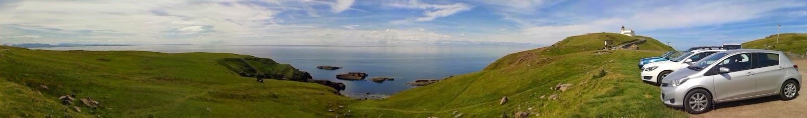
The top left corner of Scotland, CAPE WRATH!! is only reachable via a ferry and ten miles of rough track ... THROUGH A MILITARY FIRING RANGE !!  The sort of place that Top Gear would go to if it was about cycling.

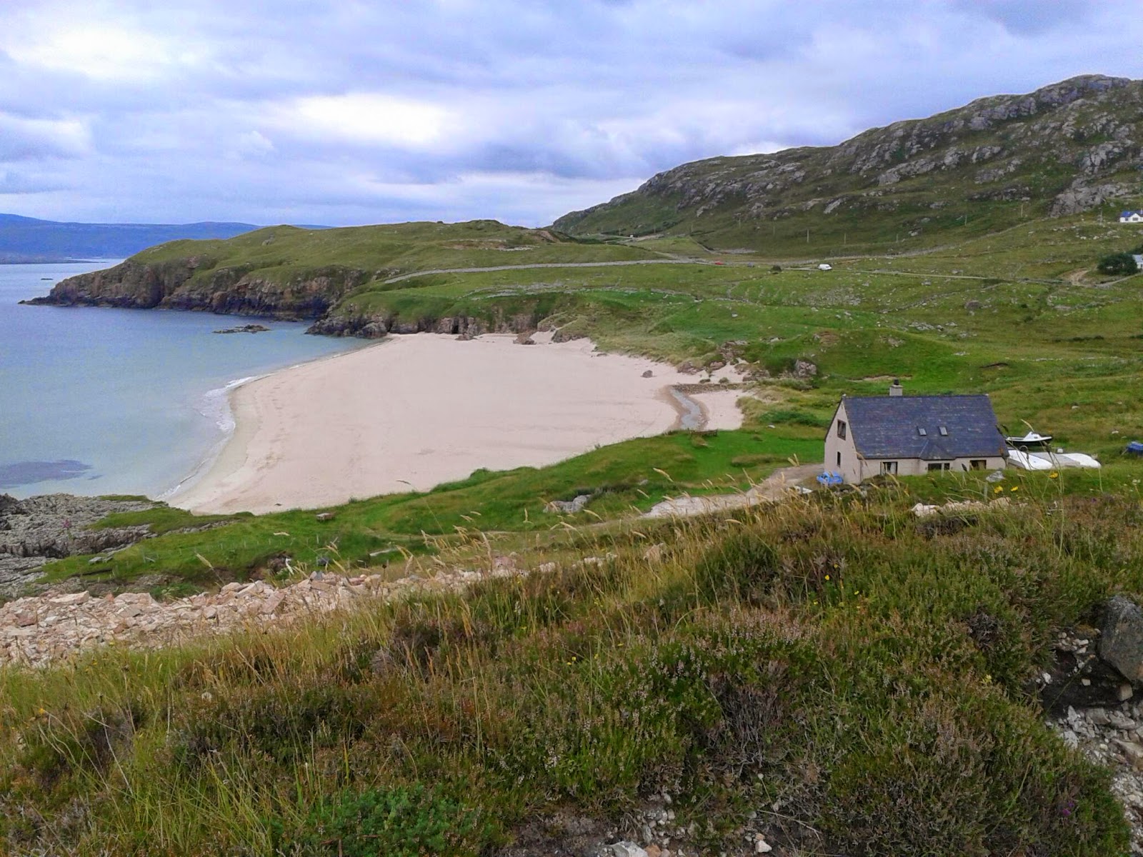
A dozen of us were waiting for the first ferry at 9:30.  Ten minutes to cross and everyone else got on the minibus.  I hid my panniers behind an abandoned tractor and started up the very steep track, which once had some tarmac on it, and varied from poor to terrible.  The first mile had nice views over the sandy sea loch, with a lone seal doing whatever seals do on the sand.

The rest was mainly a matter of spotting rideable bits of road and trying to have some influence over steering the bike.  It was hilly but my legs were fine: my hands hurt from gripping the brakes and being jarred by potholes. It made Surrey roads look good.  If you dared to look up, the views were nothing to write home about: undulating grassy, peat land with no view of the sea after the first mile.

CAPE WRATH!! is an impressive place.   Towering cliffs plunging vertically into the sea: a few seabirds making a lot of noise far below.  I was torn between getting close to the edge to see down, and wondering how safe the ground was.  There is a lighthouse,  a big foghorn,  and ... a small café selling tea, sandwiches, bananas and chocolate bars.  I sampled them all.  After the minibus left, the café closed and I seemed to have the place to myself, but there's only so much fun you can have in a place like that, so I soon headed back.  On the return journey I saw a green canister labelled GRENADE in the verge.  I decided against bringing it home as a souvenir.   Six seals on the sand as I neared the jetty.

All in all, not great as a bike ride: unless you are compelled to ride, take the minibus.  By the way, disappointingly,  CAPE WRATH!!  is derived from Norse, meaning Turning Point.

Sunday 20 July 2014

West to Durness

It just keeps getting better. ..   After a few days when I retraced my steps southwards, today's ride took me west along almost the entire North coast of Scotland.   Last night an unexpected bonus: a performance by the Thurso Pipe Band of a dozen pipers and four drummers, in the main street just outside our hostel.  Some wee lasses gave us a demonstration of highland dancing: it proved too much for one of them who ran off back to her mum half way through.

I set off early to beat the expected rain: it was a sweltering 16 º - very humid.  Empty roads on the gently rolling Caithness countryside, and a notable absence of birds, except a few blackbirds.   Very different from Orkney just a few miles away.   A few miles on was Dounreay with the domed reactor, now being decommissioned: a few miles further still and the pretty village of Reay, presumably Up Reay.

Caithness gave way to Sutherland and the hills became more serious.
A very inviting café at Bettyhill was closed on Sundays.  And that was the only café I was aware of on the whole day, so I tightened my belt (in my mind at least) and soldiered bravely on.  I needn't have worried: there was a village shop a mile further on, and then another café, very nice but beset by midges, a bit later near Tongue.   I took a detour by the estuary and missed Tongue, which may have been the only reasonably sized place on the whole route.

The views were opening up with a whole pallette of every shade of green all around, and in the distance some real mountains were emerging from the haze.  I took another gorgeous detour down a secret valley to a little sandy beach at Skerray and wound my way back past picturesque cottages and then over undulating moorland to the main road, which became single track with passing places around here.

After a few more hills I was only four miles from Durness, my destination,  but it was the other side of a big sea loch, Loch Eriboll.  The loch is surrounded by mountains and as I cycled around its three shores a succession of views unfolded.  It has the most stunning scenery I've seen so far.

And on the gentle ascent of the west side, oh joy!  A café.   I was nearly home but the views and desire for cake compelled me to stop.  Then a gently hilly and twisty ascent: more views of beautiful hillsides and beaches with pale sand and aquamarine sea hugged by black rocks.  I was in Durness but almost wished for more miles before I had to stop.  No rain either!

The last photo Iis of Smoo Cave near Durness.   Smoo means Cave in Gaelic, so it's a sort of cave cave, as you can see. Durness Youth Hostel is at the top right.

PS It has come to my notice that the Thurso Pipe Band have an Antipodean look to them. I'll have to fix this when I get home.  Sorry.