Showing posts with label NW Scotland. Show all posts

Sunday, 28 May 2017

Conclusion

I'm not quite ready to finish this year's trip, but I'm not ready to continue either. It took me ten days to cycle from London to Inverness, and then about 55 to cycle round the Highlands and Islands.  It's got under my skin: perhaps I've become a wee bit Scottish.  I'm not ready to move on yet.
When I wrote "The Final" post yesterday, I wasn't sure how to sum up this trip. After sleeping well, I woke early full of special memories.  The varying views round every corner, the downhills, the sunsets, the invisible cuckoo who followed me round, the lines of hawthorn trees across the landscape, glowing white blossom in the sun (when it shone), the centuries-old moss on the stone walls.  The amazing, fierce looking and sounding, but lovely people.
Last night Tim and I talked about the character of the four main islands.  I only have an inkling after such short visits, but they are all fascinatingly different.  You'd have to spend more time getting to know the people, the history, the politics and economy, and the land itself, to have an informed opinion. Especially on Jura, where The Long Road" only just touches the island as a whole, with its mountains, teeming rivers, and remote west and north.  Following the coast, there's plenty you don't get to see. But an uninformed opinion is fun too!
I haven't travelled far, as the cuckoo flies, from Oban. Going by bike lets you go far enough for variety, but slow enough to look around, and see the little things: the oystercatchers and the voles, the gannets diving for fish, the farmer making hay; the smells, good and bad. Time to stop when the opportunity arises, for a photo or a cafe, a chance to think about why things are as they are, and to appreciate the many things people do to make their place special.

Travelling alone has pluses and minuses.  It's great to go with friends, but, alone, you're more inclined to get into conversation with strangers, most of whom have interesting stories, if you can understand the accent.  You live more in their world.  Being alone, you can sing at the top of your voice, imitate a motor bike zooming round corners, or other inappropriate behaviour that might lead others to think you were a bit bonkers.  I don't do any of those things, of course.
Incidentally, you may have noticed that random words in these posts have been underlined: I have no idea why, or how to fix from my phone. Sorry about that.
I'll post some maps and mileages in the next day or two.

Saturday, 27 May 2017

The Final

Around the corner from Gare Loch is Helensburgh, with more reminders of re-entry into urban life. Irritating pedestrian crossings, Waitrose, crematoria instead of coastal cemeteries.  But also cafés.  I now had a simple plan, to cycle up the Clyde to Glasgow, about 30 miles. 
Interrupted by a quest to book a train ticket home.  Slight problem: no trains from Glasgow to London tomorrow.  I was at a small station, only one chap at the ticket office, as he struggled against the system for about 45 minutes to book me via Edinburgh, with bike, £37.60, not bad. And excellent service - thank you Scotrail.
On to Dumbarton, another big town with a nice Wetherspoons, and a maritime museum, but I only had time for one of them.  Some serious rain after that. The rest of the way to Glasgow was on a cycle track: initially along a canal, then a disused railway line , then a bit of industrial wasteland - all easy cycling but rather shut off from the surroundings.  There was a rash of two-storey sheds at one point - no bigger than a garden shed but twice as high. I saw perhaps a dozen of them, but couldn't work what they were for. The last three miles saw regenerated Clydeside with a nice cycle track along the river.

Arriving at Glasgow the official end point, I visited the facilities in the big Wetherspoons. You don't need to know that, but it was packed for the Cup Final. Ten minutes to go and Celtic 1, Aberdeen 1. Plenty of people wearing Celtic shirts.  Two minutes into extra time, Celtic score the winning goal and the place erupts. It was a memorable moment.
The unofficial end point was six miles further. Tim and Chris have kindly moved from Aberdeen, where I visited them five years ago, to Renfrew, near Glasgow.
I will try and sum up my thoughts on the whole trip in the next day or two, bit if you have read this far in the blog, thankyou for your company on my meanders!

Bonnie Clyde

Nice B&B, friendly Dutch host (hardly any of the B&Bs have been run by Scots for some reason).  Ferry to Gourock, across the Clyde, but I was looking back to Dunoon and the lovely ranks of hills in receding shades of blue-grey.  I was sorry to leave, after four​ years spent cycling around the Highlands from Inverness.
Dashing to catch the ferry, I didn't look at the sat nav and had caught the wrong ferry.  But it was OK, it went to a different part of Gourock and saved me a few miles cycling.
The passenger ferry back across to Kilcreggan was an altogether more informal affair: a medium sized motor launch.  Chatting with another bloke about bikes - the merits of steel versus carbon, he looks at his watch and says "Is that tge time? We'd best be going".  He was the captain. Only one other family on board with me.

First off, a trip round Gareloch, which means Short Loch: the home the British nuclear deterrent.  Obviously there are limits to what I can tell you about this highly secret location.   It was easy to spot the naval base across the loch, but disappointingly, only a couple of small surface ships were to be seen.  There was a massive crane, probably used for lifting you-know-whats into the thingumybobs.
At Garelochhead, my Garmin invited me detour away from the nice flat lochside. The planners had identified a viewpoint up the 15% hill, promising fine views down the loch.  I sweated up there, to find it was a dud. There was an information board but trees obscured the view.  I reckon it was a decoy, put there to confuse the enemy.
Back down, past the base: No Stopping; rows of razor wire; frequent police cars, but absolutely no view.  And just afterwards, a dozen brightly painted caravans in roadside woods - the Faslane Peace Camp.  Disappointing.  The only thing remotely secret I learned was the colour of the shore crew's housing, which I can tell you is ... Arrrrgh!!!

Friday, 26 May 2017

Where to next?

If you have been studying the map, you will have noticed that it gets tricky after Dunoon.  There are several more lochs off the north of the Clyde, and they don't have roads all the way around, meaning going back (over a hill) to previously travelled roads. If that sounds off-putting, bear in mind that one of the lochs is called Loch Long, and at the top of it is Arrochar, famous for the so-called Arrochar Alps.
So - when does the coast turn into the river estuary?  The only acceptable answer is "when I say it does". I'm going to make reasonable efforts.  So the plan is to avoid Loch Long (and Holy Loch) by taking two ferries, to the south bank of the Clyde and back to the north. Round Gare Loch and then into Glasgow, which is the official finish point this year.  Unless it pours with the threatened rain tomorrow, when the route might terminate early at a train station.

I actually had a plan to continue further: round the Ayrshire coast, but you have to go a long way before you get within reach of a station, and in any case, I have loved the Highlands so much - it seems only fitting to close this chapter properly.  Besides which, I've run out of toothpaste.

Over To Dunoon

The rest of the day's ride was a struggle: twenty miles over a couple of hills to Dunoon.  It wasn't a long distance, neither were the hills specially big, but it was very hot and sticky. 24° at 6pm today, possibly 28° earlier.  I didn't need those leg warmers after all. Not many views on what was mainly a forestry road, and no cafes to break up the journey to the east of the Cowal peninsula.  Emerging into the valley, Holy Loch was spread out before me like the Promised Land, only a few miles to go to Dunoon, overlooking the junction of the Clyde with Holy Loch.
There was the option to continue back round the base of the peninsula, a thirty mile round trip on a dead end road. Stuff that. I was hot, thirsty, tired and my legs had gone on strike. It was straight to the B&B.

Dunoon's a big, nice town. Multiple shopping streets - that big.  It has a (tourism) centre with piers, formal gardens, castle etc, and biggish houses strung out for a mile either side along the esplanade, mostly B&Bs and guest houses. Definitely back in civilisation.  Sun is in the wrong place for photos - maybe tomorrow.  
A very carefully calculated recovery meal to ensure I'm in tip-top condition tomorrow. Chicken (protein), plus rice AND spuds (carbs), and of course cauliflower (because you have to) in the form of a chicken muglai with aloo gobi. With appropriate hydration, of course.  I'm just not sure about the portion control aspects.  I know you need to eat a lot of calories for intensive cycling, especially where hills are involved, but I'm not sure stuffing yourself to a standstill is the best way.

Thursday, 25 May 2017

Argyll's Secret Coast

It's been a great day. Everything: a variety of interesting views, hilly, flat: lots of different terrain, bike and legs going well, great weather, and a few unexpected finds.
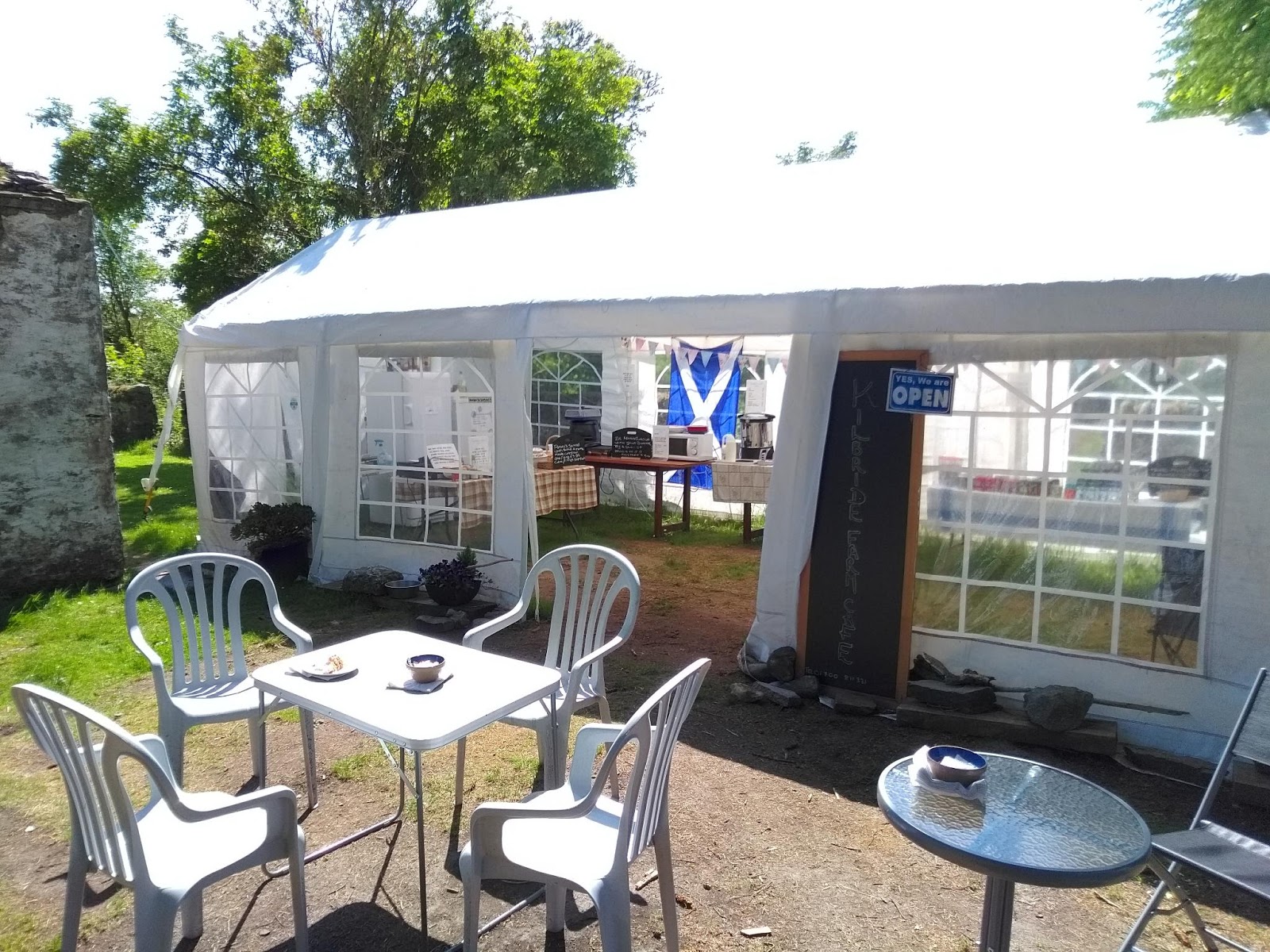
By lunchtime I was at Portavadie, but without lunch. A local told me about a café in a marquee just down the road. Run by two catering professionals as a hobby, it had everything you could want, including the best ever carrot cake.  Two other cyclists told me about an amazing beach a mile down a track nearby, and it lived up to the promise: miles of golden sand, views across to Arran, almost deserted.  Could have spent a day there, but that would be a different holiday.

I was heading round the Cowal Peninsula, "Argyll's secret coast".  Round the bottom with views across to Arran, and another 11/10 beautiful road heading north alongside the Kyle of Bute, massive pine clad hills to my left and views across to Bute on my right.  This led to Kames and Tighnabruich, two upmarket places on the top left corner of the Kyle.  Easy riding so far, but Tighnabruich means House on the Bank: grand houses built on the steep slope overlooking the Kyle to the south. The road climbs steeply up the hill, with a few great views of Bute from the top.  Another lovely coast-side road leads to Colintraive, a four-house ferry terminal village.  The crossing to Bute is so short that you could line up three ferries end to end and make a bridge.  £2 return: not bad.

Around Loch Fyne

As I got ready to go, a couple of German cyclists were getting their luggage ready to go. A mountain of panniers, tent bags and other stuff.  They were looking, well staring, enviously at my single pannier.  We swapped info about mileages, length of trip, etc - they are here for six weeks so they had to bring everything.
The loch was a mirror, with sunlight pouring through a small hole in the cloud at the head of the loch - where I was headed.  The thought of the Germans' panniers propelled me round the head of the loch.  Still very little traffic, considering this is the main road from Glasgow to Oban (which incidentally I was quite close to after the long  ride north along the loch).   Tiny Loch Gilp  on the other side passed in a pathetic instant. 
The weather forecast is for sunshine and 18°, but I think God was having a lie-in, and He only switched the sun on around ten o'clock.
After elevenses at Strachur, the sun came out properly and there was an enchanting 15 mile ride along the single-track B8000.  Weare Street on steroids.  Sea on one side, moss-encrusted woods on the other.  I passed a good sized village hall, the Strathlachan Community Centre.  Parking for maybe 30 cars. But no houses anywhere in sight. After half a mile there were four four neat cottages, white painted with pastel detailing, the only clientele for the community centre.  On the loch, mist was rolling in again, but it was mostly confined to the opposite bank.
After 15 glorious miles, I came to the appropriately named Pub By The Sea at Otterferry, and the loveliness knob was turned down from 11 to about 9.  It got seriously hilly.  A row of wind-felled pines mooned at me, baring their flat bottoms to the road.
I visited Portavadie (the other side of the Tarbert ferry), although it was out of my way.  The morning ferries had been cancelled due to fog, and the evening ferries too, due to low tides.

Wednesday, 24 May 2017

Inveraray

Easy riding up the lochside, although the mist turned to drizzle and the view of the other bank disappeared.  At Ardrishaig the puny Loch Gilp turns off, a pimple on the back of the mighty Loch Fyne.  It's also the other end of the Crinan Canal, so I followed the towpath,elevated a bit above the main road, for a couple of miles to Lochgilphead, which is - oh, you already know.

The dreich weather continued as I continued my atmospheric ride along the loch.
Despite what you've heard, it is not a long way to Inveraray.  Long, gradual ups and downs on a good road, not much traffic, nice views on a sunny day (I guess).  Plenty of cafés.  But it might be a long way from Inveraray tomorrow.  I would say it's a well-to-do place, with an impressive high street, several touristy shops, a nice castle, and a famous jail.  Good youth hostel too, if a bit smelly.  Just in front of the Inveraray Shinty Club.
After two recommendations, I ate at the George Hotel. Excellent food and service despite​ being packed: it's a well-run money-making machine, and they deserve to be successful.

Tootling up to Tarbert

Mist rolling in from the sea this morning. Tick: been there, seen that.  After a doze on the early ferry back to Claonaig, I set out on the road to, well nowhere in particular, around the shore to Skipness, where I chanced upon a castle dating from around 1300. And while admiring the rather fine turreted house next door, I realised there was a deer right in front of me, among the tables of the less fine café (look carefully at the photo).
It's a gentle, dank, autumnal May morning.  Lovely day for going nowhere, enjoying the smells of pine and wild garlic. After ten miles, I'm back at the ferry terminal, ready to head to Inveraray.

... Following which there was a short intermission, a few hills and I was back at Kennacraig, from where I'd set out for Islay five dsys ago. Still zig-zagging. Just across the peninsula is Tarbert, on Loch Fyne: a nice mix of working fishing town and marina, a welcome elevenses stop overlooking the harbour.  From Tarbert you can catch a ferry across Loch Fyne to Portavadie, missing out an 86 mile circuit around the head of the loch.  But where's the fun in that?  I'm off to Inveraray.

Monday, 22 May 2017

The interesting way back from Kintyre

The B road up the east of Kintyre is everything that the western A road is not.  Hilly, winding, interesting, downwind.  Plenty of chevrons to entertain the legs, and a different sea view round every corner to delight the eyes. I'm told it was the inspiration for the Beatles' song The Long And Winding Road.  Hedgerows full of campions, and the few houses that I passed had glorious displays of azaleas, which seem to grow well round here.

Not many villages, but conveniently about halfway is the small village of Carradale, with a post office cum tearoom, another café, and several hotels. How they all find business I don't know. Perhaps it's a base for walking.  The Carradale Hotel was closed for meals but doing an extensive range of snacks, so I had several.  One of the other clients told me that the rest of the road to Claonaig, where I catch the ferry was "interesting" by which he meant more hilly, winding, etc. than what I'd just done.
He was right, it was more interesting, in a good way. The sun came out.  The last 15 miles are single track and very varied, with great views over to Arran, looking majestic in the sunlight.
About 5pm a threatening bank of black cloud rolled over and headed towards Arran.  As I reached the ferry port at Claonaig, the heavens opened in a biblical downpour.  I sat in the shelter, counting my blessings.  30 minutes later when the Arran ferry arrived it was merely raining and I dashed aboard.   When I asked for a return ticket, the chap said "I tell you what pal, as it's such an awfu' day, you just go on in and get dry, and I'll give you a ticket for the way back.". No charge.  What can you say except thankyou?

Mull of Kintyre

Campbeltown is a big place - it even has outskirts.  Lots of shops and places to eat, and a nice, modern hostel.  Worst ever porridge for breakfast, owing to a misunderstanding about the direction the knob worked.  It took ages to get hot, and then simmered fiercely until it was ready.
About three miles out of town, the hills started.   "Lots of chevrons" I had noted when planning the route. The wind was less fierce, and I was sheltered from it a lot of the time.  To call it peaceful is an understatement. Zero cars for the first nine miles.  I actually saw a cuckoo too.

Then, out of nowhere, a traffic jam!  A car coming the other way, a farmer and his dog on a quad bike, and me.  Well, words were spoken, but they were friendly, and without road rage.

Trying not to sing The Song.  I thought I saw mist rolling in from the sea at one point, but it was just my dirty spectacles.  Good views across to the Ayrshire coast, and the rocky island of Ailsa Craig, which is interesting mainly because there was a house by that name on my paper round in Sidmouth. I always wondered what it meant.


The hilly west gave way to the smoother south with a nice long descent. I was in Southend, quite unlike its Essex twin, a small village with a tea room.  Nice.  "You should have been here yesterday" said the waitress. "There were about twenty cyclists here." A gentle ride along the south coast turned into a gentle ride up a valley, brutally ended when the road decided to go across the steep-sided valleys.  Regretfully I couldn't take the 14 mile detour to the the Mull of Kintyre lighthouse, where Ireland is only about 15 miles away.  I had a ferry to catch, up at the top of the Kintyre peninsula.

Sunday, 21 May 2017

The spice of life

Five star hospitality at Glenmachrie B&B. My Aga-dried washing was delivered outside my room in the morning. A breakfast spread worthy of a top hotel. I settled for just four courses: grapefruit with added healthy seeds, porridge, eaten with a traditional spoon made of Highland cow's horn; full Scottish breakfast with haggis (perhaps an acquired taste?). And ... well, I had to take the fourth course with me to eat later: one of the four homemade scones on my table.  It would be rude not to.
Outside it was grey, rainy and windy.  A good day to be on a ferry.  Aboard, I was greeted like a long-lost friend by the lady from the Ballygrant stores & café.  Goodbye, Islay.

There are of course many islands that I haven't visited.  I regret not visiting Colonsay, which has about 15 miles of road and a brewery, but with two ferry trips it would take a whole day.  Coll and Tiree are a bit bigger, but the ferry timings are worse, requiring at least three days if you want to spend time on both islands.  Then there are the many outlying Shetland and Orkney islands, and Rhum, Eigg and Muck near Skye.  But I reckon you would have to do a lot more than cycling to get the most out of a trip to any of these.

The ferry set off on dreadful weather but arrived in the dry: the rain had headed off north.  Yesss!  Leaving Kennacraig I set off south on the main road to Campbeltown, which heads down the west coast of the Kintyre peninsula, the fourth of the fingers that I started at Ardfern. It's much bigger than the other fingers: so big that you can see it from London, at least you can on the weather map.
The main road was unremarkable except for the headwind.  To spice things up a bit, I left the main road to try out a track which ran for a couple of miles along the sea. It looked ok on Google satellite view.  Well if variety is the spice of life, this was at least a Vindaloo.  It had been resurfaced by a herd of cows, so there were hoof marks everywhere.  It ran between the sea and one of those enchanted woods where the trees amd rocks are covered with moss and Old Man's beard lichen, so parts were worth the trip. Then there were several twenty metre stretches that were completely under water, with bog all around. But I was committed by then, and I made it at the cost of filthy wheels and a case of bog foot.


Halfway to Campbeltown is Gigha, a long thin island with a 20 minute ferry crossing.  As we approached, there were quite a big group of cyclists coming down to the slipway.  I waved hello and then recognised Ann Bath, Steve Gordon and Neil Guild, who were doing a tour in the other direction. Not much time to chat but Ann warned me about some hills on the Mull of Kintyre, the bit below Campbeltown.  My second ever selfie is attached as evidence: that's my "how do you work this thing?" expression.

People had said Gigha is beautiful, but I think it's mainly known for its extensive gardens, which I didn't visit.  The road, running from top to bottom, is ok, with some lovely hedgerow flowers, and a few rather nice bays in the north.  And a Michelin listed café near where you wait for the ferry.  Cake was served with fruit of the forest and cream, and a spoonful of stewed rhubarb which no doubt had a much more expensive name.  The economy drive starts soon. 
I can tell you something else about the main Campbeltown road. It's long.  Very long, much like this blog post, a bit of an endurance test.  Even though it's​ pretty flat, by the time I reached Campbeltown I felt as if I'd climbed an alpine pass.  Without sny lunch, save for a posh breakfast scone and a cake.