The statisticians have been at work, and the results show that this was the hilliest part of the coast so far.
Interpreting the hilliness factor:
0-50% : flat
50-80%: quite flat
80-120%: average
120-180%: hilly
180-220%: very hilly
220-280%: extremely hilly
280%+ : ridiculous
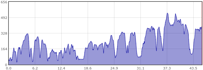
Four of the days score as "ridiculously hilly", something which my legs would agree with. Five of the days have entered the Top 10 hilly days of the whole coastal ride (see below). As you can see the mileages were not very high, but the hillages (ascent) were considerable, especially with a heavily loaded bike.
Maps
 |
| Day 1: Taunton/Bridgwater to Minehead |
 |
(distance shown includes my train journey from home)
|
 |
| Day 2: Minehead to Lynton |
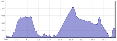 |
| Selworthy Beacon and Porlock Hill clearly shown! |
 |
| Day 3: Lynton to Yelland (Barnstaple) |
 |
| Includes part of the Tarka Trail at the end |
 |
| Day 4: Yelland to Elmscot |
 |
| Day 5: Elmscott to Tintagel |
 |
| Day 6: Tintagel to Treyarnon Bay |
 |
| Including a part of the Camel trail |
 |
| Day 6: Treyarnon Bay to Porthtowan |
 |
| Day 7: Porthtowan to YHA Lands End |
 |
| Day 8: YHA Lands End to Penzance |
Top 10 hilly days


No comments:
Post a Comment
Thanks for commenting! I do get to see the comments but it's not easy to reply when I'm on a ride.